|
|
Antenna Structure Registration 1012929 |
 |
Registration Info | Registration Number: 1012929 |
| File Number: A0015509 |
| FAA Study: 99-ACE-0598-OE |
| FAA Issue Date: 06/09/1999 |
| Status: Dismantled |
| Date Constructed: 07/31/1978 |
| NEPA: N |
Structure Info
| Structure Type: TOWER |
| Structure Coordinates: 39-10-0.0 N 91-51-44.0 W (NAD 83) |
| Structure Coordinates: 39-09-59.9 N 91-51-43.4 W (Converted to NAD 27) |
| Structure Address: 1705 East Liberty |
| Structure City: Mexico, MO |
| Structure County: Audrain County |
| Painting & Lighting Info |
FAA Circular #: 70/7460-1J |
FAA Chapters: 3, 4, 5, 13 |
Remarks: PREVIOUS FAA 96-ACE-1430-OE. |
| Elevation Info |
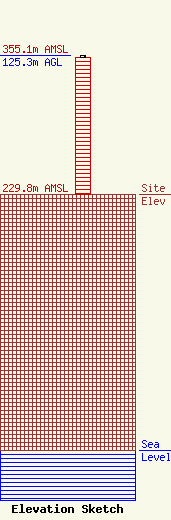
Site Elevation: 229.8 meters (754 ft) |
| Height of Structure: 123.6 meters (406 feet) |
| Overall Height Above Ground: 125.3 meters (411 feet) |
| Overall Height Above Mean Sea Level: 355.1 meters (1165 feet) |
| Owner Info | KXEO RADIO, INC.
475
MEXICO, MO 65165
(573) 581-5500
|
