|
|
Antenna Structure Registration 1013172 |
 |
Registration Info | Registration Number: 1013172 |
| File Number: A0388426 |
| FAA Study: 97-ASO-1081-OE |
| FAA Issue Date: 06/03/1998 |
| Status: Granted |
| Date Constructed: 01/01/1988 |
| NEPA: N |
Structure Info
| Structure Type: TOWER |
| Structure Coordinates: 18-23-25.0 N 66-59-44.0 W (NAD 83) |
| Structure Coordinates: 18-23-32.2 N 66-59-45.4 W (Converted to NAD 27) |
| Structure Address: Hwy 446r |
| Structure City: Isabela, PR |
| Structure County: Isabela Municipio |
| Painting & Lighting Info |
FAA Circular #: 70/7460-1J |
FAA Chapters: 3, 4, 5, 13 |
Remarks: STRUCTURE REACHED GREATEST HEIGHT 12/31/98 |
| Elevation Info |
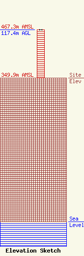
Site Elevation: 349.9 meters (1148 ft) |
| Height of Structure: 117.2 meters (385 feet) |
| Overall Height Above Ground: 117.4 meters (385 feet) |
| Overall Height Above Mean Sea Level: 467.3 meters (1533 feet) |
| Owner Info | ARZUAGA, JOSE J
980
QUEBRADILLAS, PR 00678
(787) 895-0000
|
