|
|
Antenna Structure Registration 1013956 |
 |
Registration Info | Registration Number: 1013956 |
| File Number: A0493406 |
| FAA Study: 2005-AWP-655-OE |
| FAA Issue Date: 02/14/2005 |
| Status: Constructed |
| Date Constructed: 02/26/2006 |
| FAA EMI: N |
| NEPA: N |
Structure Info
| Structure Type: TOWER |
| Structure Coordinates: 39-56-46.0 N 121-43-21.0 W (NAD 83) |
| Structure Coordinates: 39-56-46.4 N 121-43-17.1 W (Converted to NAD 27) |
| Structure Address: 10575 Cohasset Rd |
| Structure City: Chico, CA |
| Structure County: Butte County |
| Painting & Lighting Info |
FAA Circular #: 70/7460-1J |
FAA Chapters: 3, 4, 5, 13 |
Remarks: PRIOR STUDY 1997-AWP-268-OE |
Remarks: Removed expiration date from determination. Scenario 1./jjs/case#635066 |
Remarks: OM&L to remain the same as prior study = PAINT/RED LIGHTS |
Remarks: PRIOR STUDY 1997-AWP-268-OE |
Remarks: Removed expiration date from determination. Scenario 1./jjs/case#635066 |
Remarks: OM&L to remain the same as prior study = PAINT/RED LIGHTS |
| Elevation Info |
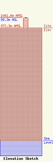
Site Elevation: 972.3 meters (3190 ft) |
| Height of Structure: 88.3 meters (290 feet) |
| Overall Height Above Ground: 89.3 meters (293 feet) |
| Overall Height Above Mean Sea Level: 1061.6 meters (3483 feet) |
| Owner Info | DEER CREEK BROADCASTING, LLC
2225 FIRST AVENUE
NAPA, CA 94558
(707) 226-2309
JMCSORLEY@SBCGLOBAL.NET |
| Contact Info | DICKSTEIN SHAPIRO MORIN & OSHINSKY LLP
2101 L STREET, NW
WASHINGTON, DC 20037-1526
ANDREW KERSTING
(202) 955-6631
KERSTINGA@DSMO.COM |
