|
|
Antenna Structure Registration 1014242 |
 |
Registration Info | Registration Number: 1014242 |
| File Number: A0740309 |
| Status: Constructed |
| Date Constructed: 01/01/1958 |
| FAA EMI: N |
| NEPA: N |
Structure Info
| Structure Type: TOWER |
| Structure Coordinates: 38-40-18.0 N 90-32-17.0 W (NAD 83) |
| Structure Coordinates: 38-40-17.8 N 90-32-16.6 W (Converted to NAD 27) |
| Structure Address: 14847 Olive St Rd |
| Structure City: Chesterfield, MO |
| Structure County: St. Louis County |
| Painting & Lighting Info |
FCC Paragraph(s): None |
| Elevation Info |
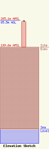
Site Elevation: 199.6 meters (655 ft) |
| Height of Structure: 62.5 meters (205 feet) |
| Overall Height Above Ground: 65.5 meters (215 feet) |
| Overall Height Above Mean Sea Level: 265.2 meters (870 feet) |
| Owner Info | St. Louis Co. Emergency Comm. System Commission
7900 Forsyth Boulevard, Suite B-144
Clayton, MO 63105
(314) 615-2562
dbarney@stlouisco.com |
