|
|
Antenna Structure Registration 1014477 |
 |
Registration Info | Registration Number: 1014477 |
| File Number: A1206193 |
| FAA Study: 96-AGL-3852-OE |
| FAA Issue Date: 10/01/1997 |
| Status: Constructed |
| Date Constructed: 02/02/1998 |
| FAA EMI: N |
| NEPA: N |
Structure Info
| Structure Type: TOWER |
| Structure Coordinates: 44-2-25.0 N 92-13-6.0 W (NAD 83) |
| Structure Coordinates: 44-02-25.1 N 92-13-05.4 W (Converted to NAD 27) |
| Structure Address: 3.1 Mi Ne Of Int Sr 42 & Us 14 Approx 3.4 Mi N |
| Structure City: Eyota, MN |
| Structure County: Olmsted County |
| Painting & Lighting Info |
FAA Circular #: 70/7460-1J |
FAA Chapters: 3, 4, 5, 13 |
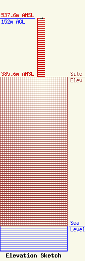
| Elevation Info |
Site Elevation: 385.6 meters (1265 ft) |
| Height of Structure: 152 meters (499 feet) |
| Overall Height Above Ground: 152 meters (499 feet) |
| Overall Height Above Mean Sea Level: 537.6 meters (1764 feet) |
| Owner Info | Townsquare Media Rochester, LLC
1 Manhattanville Road
Purchase, NY 10577
(203) 861-0900
fcccontact@townsquaremedia.com |
| Contact Info | Townsquare Media Rochester, LLC
1 Manhattanville Road
Purchase, NY 10577
(203) 861-0900
fcccontact@townsquaremedia.com |
