|
|
Antenna Structure Registration 1014678 |
 |
Registration Info | Registration Number: 1014678 |
| File Number: A1150386 |
| Status: Constructed |
| Date Constructed: 01/01/1986 |
| FAA EMI: N |
| NEPA: N |
Structure Info
| Structure Type: TOWER |
| Structure Coordinates: 39-15-32.0 N 119-42-10.0 W (NAD 83) |
| Structure Coordinates: 39-15-32.3 N 119-42-06.4 W (Converted to NAD 27) |
| Structure Address: Mcclellan Peak |
| Structure City: Carson City, NV |
| Structure County: Storey County |
| Painting & Lighting Info |
FCC Paragraph(s): 1, 3, 11, 21 |
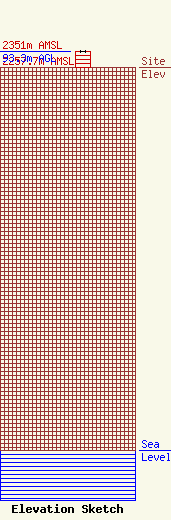
| Elevation Info |
Site Elevation: 2257.7 meters (7407 ft) |
| Height of Structure: 92.4 meters (303 feet) |
| Overall Height Above Ground: 93.3 meters (306 feet) |
| Overall Height Above Mean Sea Level: 2351 meters (7713 feet) |
| Owner Info | Cumulus Radio, LLC
3280 Peachtree Rd, Suite 2200
Atlanta, GA 30305
(404) 949-0700
towermanagement@cumulus.com |
| Contact Info | Cumulus Radio, LLC
2300 Vartan Way, Suite 130
Harrisburg, PA 17110
(717) 901-0720
dave.supplee@cumulus.com |
