|
|
Antenna Structure Registration 1014708 |
 |
Registration Info | Registration Number: 1014708 |
| File Number: A1224781 |
| FAA Study: 2021-AGL-30697-OE |
| FAA Issue Date: 10/06/2022 |
| Status: Constructed |
| Date Constructed: 09/25/1990 |
| NEPA: N |
Structure Info
| Structure Type: LTOWER |
| Structure Coordinates: 41-26-32.4 N 81-29-28.1 W (NAD 83) |
| Structure Coordinates: 41-26-32.2 N 81-29-28.7 W (Converted to NAD 27) |
| Structure Address: 26501 Renaissance Pky (075037 / Cleveland (wclv)) |
| Structure City: Cleveland, OH |
| Structure County: Cuyahoga County |
| Painting & Lighting Info |
FCC Paragraph(s): A2, H |
Remarks: PRIOR STUDY 2013-AGL-5223-OE |
Remarks: Continue As Is OM&L = 24-HR MED-STROBES |
Remarks: PRIOR STUDY 2013-AGL-5223-OE |
Remarks: Continue As Is OM&L = 24-HR MED-STROBES |
| Elevation Info |
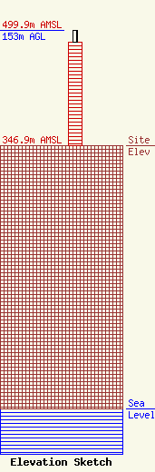
Site Elevation: 346.9 meters (1138 ft) |
| Height of Structure: 137.8 meters (452 feet) |
| Overall Height Above Ground: 153 meters (502 feet) |
| Overall Height Above Mean Sea Level: 499.9 meters (1640 feet) |
| Owner Info | American Towers LLC
10 Presidential Way
Woburn, MA 01801
(781) 926-4500
faa-fcc@americantower.com |
| Contact Info | American Towers LLC
10 Presidential Way
Woburn, MA 01801
(781) 926-4500
faa-fcc@americantower.com |
