|
|
Antenna Structure Registration 1014905 |
 |
Registration Info | Registration Number: 1014905 |
| File Number: A1309376 |
| FAA Study: 84-AWP-256-OE |
| FAA Issue Date: 03/17/1989 |
| Status: Constructed |
| Date Constructed: 10/01/1984 |
| NEPA: N |
Structure Info
| Structure Type: TOWER |
| Structure Coordinates: 38-42-38.0 N 121-28-58.0 W (NAD 83) |
| Structure Coordinates: 38-42-38.4 N 121-28-54.2 W (Converted to NAD 27) |
| Structure Address: 820 W Delano St |
| Structure City: Elverta, CA |
| Structure County: Sacramento County |
| Painting & Lighting Info |
FAA Circular #: 70/7460-1F |
FAA Chapters: 3, 4, 5, 9 |
Remarks: RED LIGHTS/PAINT |
| Elevation Info |
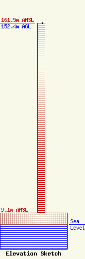
Site Elevation: 9.1 meters (30 ft) |
| Height of Structure: 152.4 meters (500 feet) |
| Overall Height Above Ground: 152.4 meters (500 feet) |
| Overall Height Above Mean Sea Level: 161.5 meters (530 feet) |
| Owner Info | California State University of Sacramento
7055 Folsom Blvd
Sacramento, CA 95826
(916) 278-8900
r.kay@capradio.org |
| Contact Info | California State University of Sacramento
7055 Folsom Blvd
Sacramento, CA 95826
Robert Kay
(916) 278-8900
r.kay@capradio.org |
