|
|
Antenna Structure Registration 1014906 |
 |
Registration Info | Registration Number: 1014906 |
| File Number: A0017811 |
| FAA Study: 90-AWP-881-OE |
| FAA Issue Date: 01/28/1991 |
| Status: Constructed |
| Date Constructed: 03/31/1991 |
| NEPA: N |
Structure Info
| Structure Type: TOWER |
| Structure Coordinates: 38-16-25.0 N 121-30-15.0 W (NAD 83) |
| Structure Coordinates: 38-16-25.3 N 121-30-11.2 W (Converted to NAD 27) |
| Structure Address: 1400 Twin Cities Rd |
| Structure City: Walnut Grove, CA |
| Structure County: Sacramento County |
| Painting & Lighting Info |
FAA Circular #: 70/7460-1G |
FAA Chapters: 3, 4, 5, 9 |
Remarks: RED LIGHTS/PAINT |
| Elevation Info |
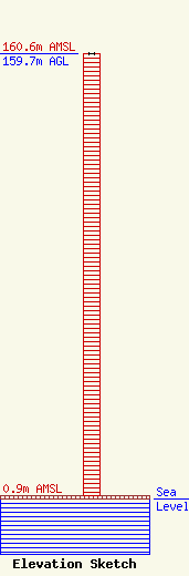
Site Elevation: 0.9 meters (3 ft) |
| Height of Structure: 159.7 meters (524 feet) |
| Overall Height Above Ground: 159.7 meters (524 feet) |
| Overall Height Above Mean Sea Level: 160.6 meters (527 feet) |
| Owner Info | CALIFORNIA STATE UNIVERSITY SACRAMENTO DBA = RADIO STATION KXPR
3416 AMERICAN RIVER DR STE B
SACRAMENTO, CA 95864
(916) 485-5977
KXPR-KXJZ@CSUS.EDU |
