|
|
Antenna Structure Registration 1015161 |
 |
Registration Info | Registration Number: 1015161 |
| File Number: A0861659 |
| Status: Constructed |
| Date Constructed: 07/01/1993 |
| FAA EMI: N |
| NEPA: N |
Structure Info
| Structure Type: TOWER |
| Structure Coordinates: 36-31-48.0 N 121-36-35.0 W (NAD 83) |
| Structure Coordinates: 36-31-48.1 N 121-36-31.2 W (Converted to NAD 27) |
| Structure Address: Mount Toro 10 Mi S |
| Structure City: Salinas, CA |
| Structure County: Monterey County |
| Painting & Lighting Info |
FCC Paragraph(s): None |
| Elevation Info |
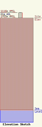
Site Elevation: 1055 meters (3461 ft) |
| Height of Structure: 61 meters (200 feet) |
| Overall Height Above Ground: 61 meters (200 feet) |
| Overall Height Above Mean Sea Level: 1116 meters (3661 feet) |
| Owner Info | PEDRAZZI PARTNERSHIP
850 RIVER ROAD
SALINAS, CA 93908
DAVID PEDRAZZI
(831) 809-4999
pedrazzifarms@aol.com |
| Contact Info | PEDRAZZI PARTNERSHIP
850 RIVER ROAD
SALINAS, CA 93908
DAVID PEDRAZZI
(831) 809-4999
pedrazzifarms@aol.com |
