|
|
Antenna Structure Registration 1015248 |
 |
Registration Info | Registration Number: 1015248 |
| File Number: A1099914 |
| FAA Study: 91-ACE-0400-OE |
| FAA Issue Date: 08/07/1991 |
| Status: Constructed |
| Date Constructed: 05/12/1949 |
| FAA EMI: N |
| NEPA: N |
Structure Info
| Structure Type: TOWER |
| Structure Coordinates: 43-8-6.0 N 93-12-29.0 W (NAD 83) |
| Structure Coordinates: 43-08-06.1 N 93-12-28.3 W (Converted to NAD 27) |
| Structure Address: 421 19th St Sw |
| Structure City: Mason City, IA |
| Structure County: Cerro Gordo County |
| Painting & Lighting Info |
FAA Circular #: 70/7460-1G |
FAA Chapters: 3, 4, 5, 9 |
| Elevation Info |
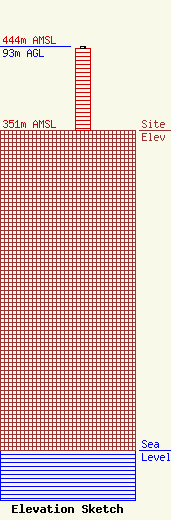
Site Elevation: 351 meters (1152 ft) |
| Height of Structure: 91 meters (299 feet) |
| Overall Height Above Ground: 93 meters (305 feet) |
| Overall Height Above Mean Sea Level: 444 meters (1457 feet) |
| Owner Info | Vertical Bridge S3 Assets, LLC
750 Park of Commerce Dr.
Boca Ratonq, FL 33487
(561) 406-4015
FCC-FAA@verticalbridge.com |
| Contact Info | Vertical Bridge S3 Assets, LLC
750 Park of Commerce Dr.
Boca Ratonq, FL 33487
Richard Hickey
(561) 406-4015
FCC-FAA@verticalbridge.com |
