|
|
Antenna Structure Registration 1015313 |
 |
Registration Info | Registration Number: 1015313 |
| File Number: A1279870 |
| FAA Study: 96-ANM-0670-OE |
| FAA Issue Date: 05/15/1997 |
| Status: Constructed |
| Date Constructed: 07/12/1998 |
| NEPA: N |
Structure Info
|
| Structure Coordinates: 43-45-44.0 N 111-57-33.0 W (NAD 83) |
| Structure Coordinates: 43-45-44.3 N 111-57-30.1 W (Converted to NAD 27) |
| Structure Address: S Menan Butte |
| Structure City: Menan, ID |
| Structure County: Madison County |
| Painting & Lighting Info |
FAA Circular #: 70/7460-1J |
FAA Chapters: 3, 4, 5, 13 |
Remarks: Removed expiration date from determination. Scenario 1./jjs/case#635066 |
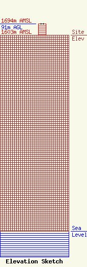
| Elevation Info |
Site Elevation: 1603 meters (5259 ft) |
| Height of Structure: 90 meters (295 feet) |
| Overall Height Above Ground: 91 meters (299 feet) |
| Overall Height Above Mean Sea Level: 1694 meters (5558 feet) |
| Owner Info | Brigham Young University-Idaho
102 UCB
Rexburg, ID 83460
(208) 496-2022
isleb@byui.edu |
| Contact Info | Wilkinson Barker Knauer, LLP
1800 M Street NW
Washington, DC 20036
David O'Connor
(202) 383-3429
doconnor@wbklaw.com |
