|
|
Antenna Structure Registration 1015314 |
 |
Registration Info | Registration Number: 1015314 |
| File Number: A1315572 |
| FAA Study: 97-ASO-0104-OE |
| FAA Issue Date: 02/06/1997 |
| Status: Dismantled |
| Date Constructed: 04/23/1997 |
| FAA EMI: N |
| NEPA: N |
Structure Info
|
| Structure Coordinates: 36-9-23.0 N 86-46-16.0 W (NAD 83) |
| Structure Coordinates: 36-09-22.8 N 86-46-16.0 W (Converted to NAD 27) |
| Structure Address: 506 Second Ave S |
| Structure City: Nashville, TN |
| Structure County: Davidson County |
| Painting & Lighting Info |
FAA Circular #: 70/7460-1J |
FAA Chapters: 4, 5, 6, 8, 13 |
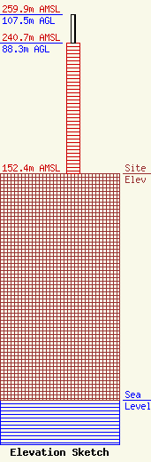
| Elevation Info |
Site Elevation: 152.4 meters (500 ft) |
| Height of Structure: 88.3 meters (290 feet) |
| Overall Height Above Ground: 107.5 meters (353 feet) |
| Overall Height Above Mean Sea Level: 259.9 meters (853 feet) |
| Owner Info | Cumulus Radio, LLC
780 Johnson Ferry Road
Atlanta, GA 30342
(404) 949-0700
towermanagement@cumulus.com |
| Contact Info | Cumulus Radio, LLC
6565 N. W Street, Suite 270
Pensacola, FL 32505
Robert Combs
(281) 755-4366
robert.combs@cumulus.com |
