|
|
Antenna Structure Registration 1015412 |
 |
Registration Info | Registration Number: 1015412 |
| File Number: A0814993 |
| FAA Study: 2008-AEA-1656-OE |
| FAA Issue Date: 07/25/2008 |
| Status: Constructed |
| Date Constructed: 07/25/2008 |
| FAA EMI: N |
| NEPA: N |
Structure Info
| Structure Type: TOWER |
| Structure Coordinates: 37-59-6.4 N 78-28-47.4 W (NAD 83) |
| Structure Coordinates: 37-59-05.9 N 78-28-48.4 W (Converted to NAD 27) |
| Structure Address: 1840 Carters Mountain Trail (090228) |
| Structure City: Charlottesville, VA |
| Structure County: Albemarle County |
| Painting & Lighting Info |
FAA Circular #: 70/7460-1K |
FAA Chapters: 4, 8, 12 |
Remarks: PRIOR STUDY 2002-AEA-983-OE |
Remarks: OM&L to remain the same as prior study = A MED-DUAL SYSTEM |
Remarks: PRIOR STUDY 2002-AEA-983-OE |
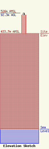
| Elevation Info |
Site Elevation: 433.7 meters (1423 ft) |
| Height of Structure: 83.5 meters (274 feet) |
| Overall Height Above Ground: 92.3 meters (303 feet) |
| Overall Height Above Mean Sea Level: 526 meters (1726 feet) |
| Owner Info | American Towers LLC
10 Presidential Way
Woburn, MA 01801
(678) 564-3236
faa-fcc@americantower.com |
| Contact Info | American Towers, LLC.
10 Presidential Way
Woburn, MA 01801
(678) 564-3236
faa-fcc@americantower.com |
