|
|
Antenna Structure Registration 1015685 |
 |
Registration Info | Registration Number: 1015685 |
| File Number: A1107422 |
| FAA Study: 71-WE-388-OE |
| FAA Issue Date: 09/16/1971 |
| Status: Constructed |
| Date Constructed: 01/01/1971 |
| FAA EMI: N |
| NEPA: N |
Structure Info
| Structure Type: TOWER |
| Structure Coordinates: 38-35-16.0 N 121-29-26.0 W (NAD 83) |
| Structure Coordinates: 38-35-16.3 N 121-29-22.2 W (Converted to NAD 27) |
| Structure Address: 3 Television Circle |
| Structure City: Sacramento, CA |
| Structure County: Sacramento County |
| Painting & Lighting Info |
FCC Paragraph(s): 1, 3, 4, 13, 21 |
Remarks: RED LIGHTS/PAINT |
| Elevation Info |
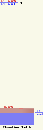
Site Elevation: 6.1 meters (20 ft) |
| Height of Structure: 167.7 meters (550 feet) |
| Overall Height Above Ground: 170.2 meters (558 feet) |
| Overall Height Above Mean Sea Level: 176.3 meters (578 feet) |
| Owner Info | Hearst Stations Inc.
1800
Raleigh, NC 27602
(919) 839-0300
shartzell@brookspierce.com |
| Info |
