|
|
Antenna Structure Registration 1015710 |
 |
Registration Info | Registration Number: 1015710 |
| File Number: A0598767 |
| FAA Study: 78-ANW-584-OE |
| FAA Issue Date: 01/04/1978 |
| Status: Constructed |
| Date Constructed: 01/01/1979 |
| FAA EMI: N |
| NEPA: N |
Structure Info
| Structure Type: TOWER |
| Structure Coordinates: 37-4-23.0 N 119-25-54.0 W (NAD 83) |
| Structure Coordinates: 37-04-23.2 N 119-25-50.5 W (Converted to NAD 27) |
| Structure Address: 41990 Radio Ln |
| Structure City: Auberry, CA |
| Structure County: Fresno County |
| Painting & Lighting Info |
FCC Paragraph(s): 1, 3, 11, 21 |
Remarks: RED LIGHTS/PAINT |
| Elevation Info |
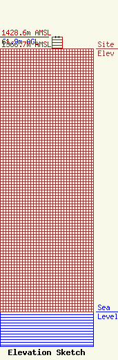
Site Elevation: 1366.7 meters (4484 ft) |
| Height of Structure: 61 meters (200 feet) |
| Overall Height Above Ground: 61.9 meters (203 feet) |
| Overall Height Above Mean Sea Level: 1428.6 meters (4687 feet) |
| Owner Info | Cocola Broadcasting Companies, LLC
706 West Herndon Avenue
Fresno, CA 93650
(559) 435-7000
|
| Contact Info | Dow Lohnes PLLC
1200 New Hampshire Avenue, NW, #800
Washington, DC 20036
Kevin Latek
(202) 776-2000
klatek@dowlohnes.com |
