|
|
Antenna Structure Registration 1015714 |
 |
Registration Info | Registration Number: 1015714 |
| File Number: A0903749 |
| FAA Study: SFO-OE-68-111 |
| Status: Constructed |
| Date Constructed: 10/01/1968 |
| FAA EMI: N |
| NEPA: N |
Structure Info
| Structure Type: TOWER |
| Structure Coordinates: 36-32-5.0 N 121-37-18.0 W (NAD 83) |
| Structure Coordinates: 36-32-05.1 N 121-37-14.2 W (Converted to NAD 27) |
| Structure Address: Mount Toro |
| Structure City: Monterey, CA |
| Structure County: Monterey County |
| Painting & Lighting Info |
FCC Paragraph(s): 1, 3, 11, 21 |
| Elevation Info |
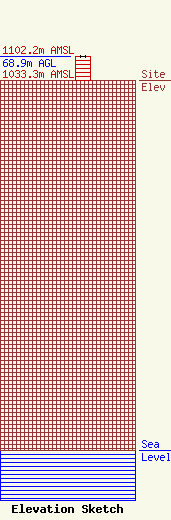
Site Elevation: 1033.3 meters (3390 ft) |
| Height of Structure: 68.9 meters (226 feet) |
| Overall Height Above Ground: 68.9 meters (226 feet) |
| Overall Height Above Mean Sea Level: 1102.2 meters (3616 feet) |
| Owner Info | NPG OF MONTEREY-SALINAS CA, LLC
C/O NEWS-PRESS & GAZETTE CO.
SAINT JOSEPH, MO 64501
(816) 271-8505
BBRADLEY@NPGCO.COM |
| Contact Info | SMITHWICK & BELENDIUK, PC
5028 WISCONSIN AVE, NW
WASHINGTON, DC 20016
ROBERT THOMPSON
(202) 363-4409
BTHOMPSON@FCCWORLD.COM |
