|
|
Antenna Structure Registration 1015865 |
 |
Registration Info | Registration Number: 1015865 |
| File Number: A1181284 |
| FAA Study: 2020-AWP-8430-OE |
| FAA Issue Date: 07/28/2020 |
| Status: Constructed |
| Date Constructed: 01/01/1985 |
Structure Info
| Structure Type: GTOWER |
| Structure Coordinates: 38-38-8.9 N 121-33-14.4 W (NAD 83) |
| Structure Coordinates: 38-38-09.2 N 121-33-10.6 W (Converted to NAD 27) |
| Structure Address: 3802 Garden Hwy (008114 / Kctc - Sacramento, T1 Ca) |
| Structure City: Sacramento, CA |
| Structure County: Sacramento County |
| Painting & Lighting Info |
FAA Circular #: 70/7460-1L |
FAA Chapters: 4, 8, 12 |
Remarks: PRIOR STUDY 2014-AWP-3178-OE |
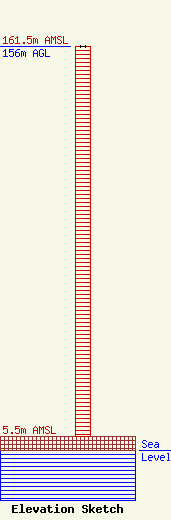
| Elevation Info |
Site Elevation: 5.5 meters (18 ft) |
| Height of Structure: 156 meters (512 feet) |
| Overall Height Above Ground: 156 meters (512 feet) |
| Overall Height Above Mean Sea Level: 161.5 meters (530 feet) |
| Owner Info | American Towers LLC
10 Presidential Way
Woburn, MA 01801
(678) 564-3236
FAA-FCC@americantower.com |
| Contact Info | American Towers, LLC.
10 Presidential Way
Woburn, MA 01801
(678) 564-3236
FAA-FCC@americantower.com |
