|
|
Antenna Structure Registration 1015904 |
 |
Registration Info | Registration Number: 1015904 |
| File Number: A0948478 |
| FAA Study: 2002-AGL-3645-OE |
| FAA Issue Date: 08/23/2002 |
| Status: Constructed |
| Date Constructed: 07/01/1966 |
| FAA EMI: N |
| NEPA: N |
Structure Info
|
| Structure Coordinates: 39-25-9.2 N 81-28-34.4 W (NAD 83) |
| Structure Coordinates: 39-25-08.9 N 81-28-35.0 W (Converted to NAD 27) |
| Structure Address: 925 Lancaster St |
| Structure City: Marietta, OH |
| Structure County: Washington County |
| Painting & Lighting Info |
FCC Paragraph(s): 1, 3, 11, 21 |
Remarks: OM&L TO REMAIN PAINT RED LIGHTS |
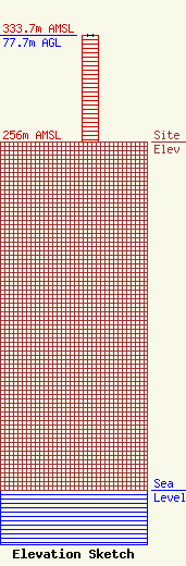
| Elevation Info |
Site Elevation: 256 meters (840 ft) |
| Height of Structure: 77.7 meters (255 feet) |
| Overall Height Above Ground: 77.7 meters (255 feet) |
| Overall Height Above Mean Sea Level: 333.7 meters (1095 feet) |
| Owner Info | JAWCO INC DBA WMOA
925 Lancaster St.
708
Marietta, OH 45750
(740) 373-1490
jwharff@wmoa1490.com |
| Contact Info | JAWCO INC DBA WMOA
925 Lancaster St.
708
Marietta, OH 45750
(740) 373-1490
jwharff@wmoa1490.com |
