|
|
Antenna Structure Registration 1015915 |
 |
Registration Info | Registration Number: 1015915 |
| File Number: A0368361 |
| FAA Study: 02-AWP-1294-OE |
| FAA Issue Date: 05/22/2002 |
| Status: Constructed |
| Date Constructed: 12/20/2000 |
| FAA EMI: N |
| NEPA: N |
Structure Info
| Structure Type: TOWER |
| Structure Coordinates: 34-20-55.0 N 119-20-0.4 W (NAD 83) |
| Structure Coordinates: 34-20-55.0 N 119-19-57.0 W (Converted to NAD 27) |
| Structure Address: Red Mountain |
| Structure City: Ventura, CA |
| Structure County: Ventura County |
| Painting & Lighting Info |
FAA Circular #: 70/7460-1K |
FAA Chapters: 3, 4, 5, 12 |
Remarks: PRIOR STUDY 01-AWP-4491-OE |
Remarks: Removed expiration date from determination. Scenario 1./jjs/case#635066 |
| Elevation Info |
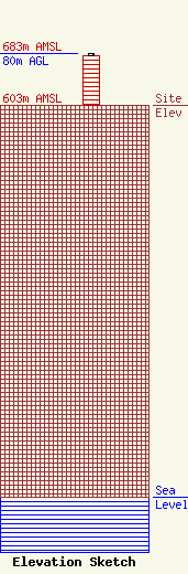
Site Elevation: 603 meters (1978 ft) |
| Height of Structure: 76 meters (249 feet) |
| Overall Height Above Ground: 80 meters (262 feet) |
| Overall Height Above Mean Sea Level: 683 meters (2241 feet) |
| Owner Info | Salem Radio Properties
4880 Santa Rosa Road, Suite 300
Camarillo, CA 93012
(805) 384-4502
carlg@salem.cc |
