|
|
Antenna Structure Registration 1015956 |
 |
Registration Info | Registration Number: 1015956 |
| File Number: A0615184 |
| Status: Constructed |
| Date Constructed: 04/01/1981 |
| FAA EMI: N |
| NEPA: N |
Structure Info
| Structure Type: TOWER |
| Structure Coordinates: 39-23-35.0 N 84-36-24.0 W (NAD 83) |
| Structure Coordinates: 39-23-34.8 N 84-36-24.2 W (Converted to NAD 27) |
| Structure Address: 770 New London Rd |
| Structure City: Hamilton, OH |
| Structure County: Butler County |
| Painting & Lighting Info |
FCC Paragraph(s): 1, 3, 11, 21 |
| Elevation Info |
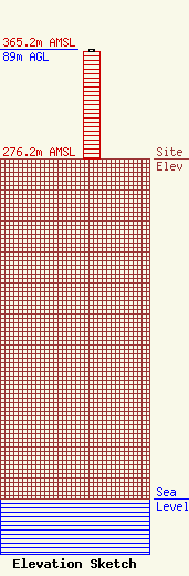
Site Elevation: 276.2 meters (906 ft) |
| Height of Structure: 86.6 meters (284 feet) |
| Overall Height Above Ground: 89 meters (292 feet) |
| Overall Height Above Mean Sea Level: 365.2 meters (1198 feet) |
| Owner Info | Conundrum Communications Investments, Inc.
80495
Rochester, MI 48308
(248) 252-2305
radiotowerdude@netzero.net |
| Info |
