|
|
Antenna Structure Registration 1015970 |
 |
Registration Info | Registration Number: 1015970 |
| File Number: A1254735 |
| FAA Study: 2023-ASO-1003-OE |
| FAA Issue Date: 07/27/2023 |
| Status: Constructed |
| Date Constructed: 04/01/1992 |
| NEPA: N |
Structure Info
| Structure Type: GTOWER |
| Structure Coordinates: 25-10-1.4 N 80-22-29.2 W (NAD 83) |
| Structure Coordinates: 25-09-60.0 N 80-22-30.0 W (Converted to NAD 27) |
| Structure Address: 1 Km Se Of Overseas Hwy Us 1 At Mil |
| Structure City: Key Largo, FL |
| Structure County: Monroe County |
| Painting & Lighting Info |
FAA Circular #: 70/7460-1M |
FAA Chapters: 4, 8, 15 |
Remarks: PRIOR STUDY 2013-ASO-4481-OE |
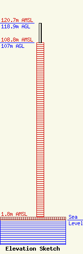
| Elevation Info |
Site Elevation: 1.8 meters (6 ft) |
| Height of Structure: 107 meters (351 feet) |
| Overall Height Above Ground: 118.9 meters (390 feet) |
| Overall Height Above Mean Sea Level: 120.7 meters (396 feet) |
| Owner Info | L3Harris Technologies, Inc.
7022 TPC Drive, Suite 400
Orlando, FL 32822
(407) 581-3782
Steve.A.Williams@L3Harris.com |
| Contact Info | L3Harris Technologies, Inc.
434 West Sand Lake Road
Wynantskill, NY 12198
Robert Isby
(518) 389-8876
Robert.Isby@L3Harris.com |
