|
|
Antenna Structure Registration 1016046 |
 |
Registration Info | Registration Number: 1016046 |
| File Number: A1149798 |
| FAA Study: 2019-AEA-13094-OE |
| FAA Issue Date: 11/20/2019 |
| Status: Constructed |
| Date Constructed: 02/14/1986 |
| NEPA: N |
Structure Info
| Structure Type: GTOWER |
| Structure Coordinates: 42-5-6.5 N 79-17-20.8 W (NAD 83) |
| Structure Coordinates: 42-05-06.3 N 79-17-21.6 W (Converted to NAD 27) |
| Structure Address: 500 Orchard Rd (204474) |
| Structure City: Jamestown, NY |
| Structure County: Chautauqua County |
| Painting & Lighting Info |
FAA Circular #: 70/7460-1L |
FAA Chapters: 4, 8, 12 |
| Elevation Info |
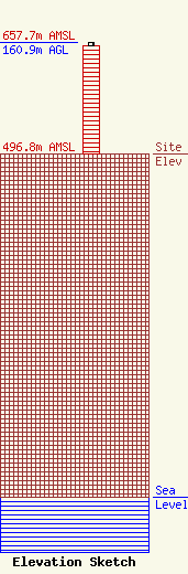
Site Elevation: 496.8 meters (1630 ft) |
| Height of Structure: 156.4 meters (513 feet) |
| Overall Height Above Ground: 160.9 meters (528 feet) |
| Overall Height Above Mean Sea Level: 657.7 meters (2158 feet) |
| Owner Info | American Towers LLC
10 Presidential Way
Woburn, MA 01801
(781) 926-4500
faa-fcc@americantower.com |
| Contact Info | American Towers, LLC
10 Presidential Way
Woburn, MA 01801
(781) 926-4500
faa-fcc@americantower.com |
