|
|
Antenna Structure Registration 1016051 |
 |
Registration Info | Registration Number: 1016051 |
| File Number: A1194712 |
| FAA Study: 01-AGL-8721-OE |
| Status: Constructed |
| Date Constructed: 01/20/2002 |
| FAA EMI: N |
| NEPA: N |
Structure Info
| Structure Type: TOWER |
| Structure Coordinates: 39-47-27.4 N 89-30-53.0 W (NAD 83) |
| Structure Coordinates: 39-47-27.2 N 89-30-52.7 W (Converted to NAD 27) |
| Structure Address: Approx 7 Mi E Of City Center |
| Structure City: Springfield, IL |
| Structure County: Sangamon County |
| Painting & Lighting Info |
FAA Circular #: 70/7460-1J |
FAA Chapters: 3, 4, 5, 13 |
| Elevation Info |
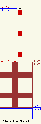
Site Elevation: 170.7 meters (560 ft) |
| Height of Structure: 201.4 meters (661 feet) |
| Overall Height Above Ground: 202.4 meters (664 feet) |
| Overall Height Above Mean Sea Level: 373.1 meters (1224 feet) |
| Owner Info | Nexstar Media Inc.
545 E. John Carpenter Freeway
Irving, TX 75062
(972) 373-8800
jasroberts@nexstar.tv |
| Contact Info | Nexstar Media Inc.
545 E. John Carpenter Freeway
Irving, TX 75062
Jason Roberts
(972) 373-8800
jasroberts@nexstar.tv |
