|
|
Antenna Structure Registration 1016059 |
 |
Registration Info | Registration Number: 1016059 |
| File Number: A1053617 |
| FAA Study: 97-AGL-0518-OE |
| Status: Constructed |
| Date Constructed: 07/31/1980 |
| NEPA: N |
Structure Info
| Structure Type: 5TA2 |
| Structure Coordinates: 38-21-15.0 N 89-0-29.0 W (NAD 83) |
| Structure Coordinates: 38-21-14.8 N 89-00-28.8 W (Converted to NAD 27) |
| Structure Address: Twr 2 .5 Mi S Of Rt 64 |
| Structure City: Mt Vernon, IL |
| Structure County: Jefferson County |
| Painting & Lighting Info |
FAA Circular #: 70/7460-1J |
FAA Chapters: 3, 4, 5, 13 |
| Elevation Info |
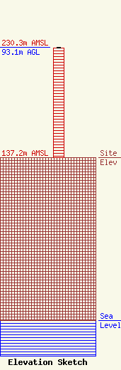
Site Elevation: 137.2 meters (450 ft) |
| Height of Structure: 92.1 meters (302 feet) |
| Overall Height Above Ground: 93.1 meters (305 feet) |
| Overall Height Above Mean Sea Level: 230.3 meters (756 feet) |
| Owner Info | WITHERS BROADCASTING COMPANY OF ILLINOIS, LLC
3501 BROADWAY STREET
1508
MOUNT VERNON, IL 62864-1508
(618) 242-3500
drw@mvn.net |
| Contact Info | SCIARRINO & SHUBERT, PLLC
4601 N. FAIRFAX DRIVE
ARLINGTON, VA 22203
(202) 256-9551
DAWN@SCIARRINOLAW.COM |
