|
|
Antenna Structure Registration 1016356 |
 |
Registration Info | Registration Number: 1016356 |
| File Number: A0816305 |
| FAA Study: 2007-AWP-2482-OE |
| FAA Issue Date: 06/18/2007 |
| Status: Constructed |
| Date Constructed: 06/18/2007 |
| FAA EMI: N |
| NEPA: N |
Structure Info
| Structure Type: TOWER |
| Structure Coordinates: 38-38-30.0 N 121-5-28.8 W (NAD 83) |
| Structure Coordinates: 38-38-30.3 N 121-05-25.0 W (Converted to NAD 27) |
| Structure Address: 14150 White Rock Rd (el Dorado South, T2 #8106) |
| Structure City: Sacramento, CA |
| Structure County: Sacramento County |
| Painting & Lighting Info |
FAA Chapters: NONE |
Remarks: PRIOR STUDY 2007-AWP-94-OE |
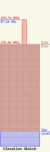
| Elevation Info |
Site Elevation: 238.6 meters (783 ft) |
| Height of Structure: 67.1 meters (220 feet) |
| Overall Height Above Ground: 67.1 meters (220 feet) |
| Overall Height Above Mean Sea Level: 305.7 meters (1003 feet) |
| Owner Info | American Towers LLC
10 Presidential Way
Woburn, MA 01801
(678) 564-3236
faa-fcc@americantower.com |
| Contact Info | American Towers, LLC.
10 Presidential Way
Woburn, MA 01801
(678) 564-3236
faa-fcc@americantower.com |
