|
|
Antenna Structure Registration 1016460 |
 |
Registration Info | Registration Number: 1016460 |
| File Number: A1219656 |
| FAA Study: 2021-AGL-16706-OE |
| FAA Issue Date: 06/30/2021 |
| Status: Constructed |
| Date Constructed: 01/01/1953 |
| NEPA: N |
Structure Info
| Structure Type: GTOWER |
| Structure Coordinates: 39-44-1.8 N 84-14-52.2 W (NAD 83) |
| Structure Coordinates: 39-44-01.6 N 84-14-52.4 W (Converted to NAD 27) |
| Structure Address: 3316 Germantown St (#209097) |
| Structure City: Dayton, OH |
| Structure County: Montgomery County |
| Painting & Lighting Info |
FAA Circular #: 70/7460-1M |
FAA Chapters: 3, 4, 5, 15 |
Remarks: PRIOR STUDY 2017-AGL-6113-OE |
| Elevation Info |
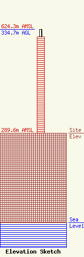
Site Elevation: 289.6 meters (950 ft) |
| Height of Structure: 310.5 meters (1019 feet) |
| Overall Height Above Ground: 334.7 meters (1098 feet) |
| Overall Height Above Mean Sea Level: 624.3 meters (2048 feet) |
| Owner Info | American Towers LLC
10 Presidential Way
Woburn, MA 01801
(781) 926-4500
faa-fcc@americantower.com |
| Contact Info | American Towers LLC
10 Presidential Way
Woburn, MA 01801
(781) 926-4500
faa-fcc@americantower.com |
