|
|
Antenna Structure Registration 1016461 |
 |
Registration Info | Registration Number: 1016461 |
| File Number: A0019748 |
| FAA Study: 96-AEA-2573-OE |
| FAA Issue Date: 02/19/1997 |
| Status: Constructed |
| Date Constructed: 08/01/1971 |
| NEPA: N |
Structure Info
| Structure Type: TOWER |
| Structure Coordinates: 43-51-46.0 N 75-43-38.0 W (NAD 83) |
| Structure Coordinates: 43-51-45.8 N 75-43-39.3 W (Converted to NAD 27) |
| Structure Address: Route 194 |
| Structure City: Copenhagen, NY |
| Structure County: Lewis County |
| Painting & Lighting Info |
FAA Circular #: 70/7460-1J |
FAA Chapters: 3, 4, 5, 13 |
| Elevation Info |
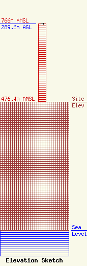
Site Elevation: 476.4 meters (1563 ft) |
| Height of Structure: 289.6 meters (950 feet) |
| Overall Height Above Ground: 289.6 meters (950 feet) |
| Overall Height Above Mean Sea Level: 766 meters (2513 feet) |
| Owner Info | ST LAWRENCE VALLEY ETV COUNCIL INC
1056 ARSENAL ST
WATERTOWN, NY 13601
(315) 782-3142
WWW.WPBS.PBS.ORG |
