|
|
Antenna Structure Registration 1016619 |
 |
Registration Info | Registration Number: 1016619 |
| File Number: A1316239 |
| FAA Study: 2024-ACE-5356-OE |
| FAA Issue Date: 03/21/2025 |
| Status: Constructed |
| Date Constructed: 01/06/1989 |
| NEPA: N |
Structure Info
| Structure Type: LTOWER |
| Structure Coordinates: 43-7-17.4 N 93-11-35.5 W (NAD 83) |
| Structure Coordinates: 43-07-17.5 N 93-11-34.8 W (Converted to NAD 27) |
| Structure Address: Us Hwy 65 To Se 35th St S |
| Structure City: Mason City, IA |
| Structure County: Cerro Gordo County |
| Painting & Lighting Info |
FAA Chapters: NONE |
Remarks: PRIOR STUDY 1988-ACE-693-OE |
Remarks: 2024-ACE-5356-OE approves NONE |
Remarks: Continue As Is OM&L = A MED-DUAL SYSTEM |
Remarks: PRIOR STUDY 1988-ACE-693-OE |
Remarks: 2024-ACE-5356-OE approves NONE |
| Elevation Info |
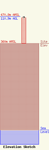
Site Elevation: 360 meters (1181 ft) |
| Height of Structure: 106.7 meters (350 feet) |
| Overall Height Above Ground: 110.9 meters (364 feet) |
| Overall Height Above Mean Sea Level: 470.9 meters (1545 feet) |
| Owner Info | Blue Sky Towers IV, LLC
352 Park Street
North Reading, MA 01864
(888) 960-7958
chuck.laurette@blueskytower.com |
| Contact Info | Blue Sky Towers IV, LLC
352 Park Street
North Reading, MA 01864
Chuck Laurette
(888) 960-7958
chuck.laurette@blueskytower.com |
