|
|
Antenna Structure Registration 1016626 |
 |
Registration Info | Registration Number: 1016626 |
| File Number: A1308817 |
| FAA Study: 2024-ACE-5602-OE |
| FAA Issue Date: 10/24/2024 |
| Status: Constructed |
| Date Constructed: 11/23/2004 |
| NEPA: N |
Structure Info
| Structure Type: LTOWER |
| Structure Coordinates: 41-38-5.2 N 93-34-45.2 W (NAD 83) |
| Structure Coordinates: 41-38-05.2 N 93-34-44.4 W (Converted to NAD 27) |
| Structure Address: 4039 Delaware Avenue |
| Structure City: Des Moines, IA |
| Structure County: Polk County |
| Painting & Lighting Info |
FAA Circular #: 70/7460-1H |
FAA Chapters: 4, 6, 13 |
Remarks: PRIOR STUDY 2003-ACE-2644-OE |
Remarks: OM&L to remain the same as prior study = 24-HR MED-STROBES |
Remarks: PRIOR STUDY 2003-ACE-2644-OE |
| Elevation Info |
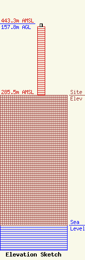
Site Elevation: 285.5 meters (937 ft) |
| Height of Structure: 150.8 meters (495 feet) |
| Overall Height Above Ground: 157.8 meters (518 feet) |
| Overall Height Above Mean Sea Level: 443.3 meters (1454 feet) |
| Owner Info | Blue Sky Towers IV, LLC
352 Park Street
North Reading, MA 01864
(888) 960-7958
chuck.laurette@blueskytower.com |
| Contact Info | Blue Sky Towers IV, LLC
352 Park Street
North Reading, MA 01864
Chuck Laurette
(888) 960-7958
chuck.laurette@blueskytower.com |
