|
|
Antenna Structure Registration 1016711 |
 |
Registration Info | Registration Number: 1016711 |
| File Number: A0631536 |
| Status: Constructed |
| Date Constructed: 01/01/1975 |
| FAA EMI: N |
| NEPA: N |
Structure Info
| Structure Type: TOWER |
| Structure Coordinates: 42-29-56.0 N 92-15-52.0 W (NAD 83) |
| Structure Coordinates: 42-29-56.0 N 92-15-51.3 W (Converted to NAD 27) |
| Structure Address: Hwy 281 E |
| Structure City: Waterloo, IA |
| Structure County: Black Hawk County |
| Painting & Lighting Info |
FCC Paragraph(s): 1, 3, 4, 13, 21 |
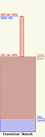
| Elevation Info |
Site Elevation: 281.9 meters (925 ft) |
| Height of Structure: 183 meters (600 feet) |
| Overall Height Above Ground: 184 meters (604 feet) |
| Overall Height Above Mean Sea Level: 465.9 meters (1529 feet) |
| Owner Info | RACOM Corp.
201 W. State St.
Marshalltown, IA 50158
(888) 752-1016
carrie.loney@racom.net |
| Contact Info | RACOM Corp.
201 W. State St.
Marshalltown, IA 50158
Carrie Loney
(888) 752-1016
carrie.loney@racom.net |
