|
|
Antenna Structure Registration 1016800 |
 |
Registration Info | Registration Number: 1016800 |
| File Number: A1054206 |
| FAA Study: 84-ACE-39-OE |
| FAA Issue Date: 04/21/1993 |
| Status: Constructed |
| Date Constructed: 01/01/1985 |
| NEPA: N |
Structure Info
| Structure Type: LTOWER |
| Structure Coordinates: 41-35-35.0 N 93-37-49.0 W (NAD 83) |
| Structure Coordinates: 41-35-35.0 N 93-37-48.2 W (Converted to NAD 27) |
| Structure Address: 888 9th St |
| Structure City: Des Moines, IA |
| Structure County: Polk County |
| Painting & Lighting Info |
FAA Circular #: 70/7460-1H |
FAA Chapters: 4, 8, 13 |
| Elevation Info |
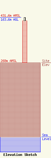
Site Elevation: 268 meters (879 ft) |
| Height of Structure: 152 meters (499 feet) |
| Overall Height Above Ground: 163.6 meters (537 feet) |
| Overall Height Above Mean Sea Level: 431.6 meters (1416 feet) |
| Owner Info | Hearst Properties Inc.
1800
Raleigh, NC 27602
(919) 839-0300
shartzell@brookspierce.com |
| Info |
