|
|
Antenna Structure Registration 1016842 |
 |
Registration Info | Registration Number: 1016842 |
| File Number: A0118602 |
| FAA Study: 96-ACE-0560-OE |
| FAA Issue Date: 07/23/1996 |
| Status: Constructed |
| Date Constructed: 03/01/1998 |
| FAA EMI: N |
| NEPA: N |
Structure Info
| Structure Type: 2TA1 |
| Structure Coordinates: 37-14-28.0 N 97-24-5.0 W (NAD 83) |
| Structure Coordinates: 37-14-27.9 N 97-24-03.8 W (Converted to NAD 27) |
| Structure Address: Twr 1 - 338 S Kley Dr |
| Structure City: Wellington, KS |
| Structure County: Sumner County |
| Painting & Lighting Info |
FAA Circular #: 70/7460-1J |
FAA Chapters: 3, 4, 5, 13 |
| Elevation Info |
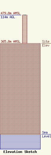
Site Elevation: 365.8 meters (1200 ft) |
| Height of Structure: 114 meters (374 feet) |
| Overall Height Above Ground: 114 meters (374 feet) |
| Overall Height Above Mean Sea Level: 479.8 meters (1574 feet) |
| Owner Info | JOHNSON ENTERPRISES INC
338 S KLEY DR
WELLINGTON, KS 67152
(316) 326-3341
|
