|
|
Antenna Structure Registration 1016954 |
 |
Registration Info | Registration Number: 1016954 |
| File Number: A0934691 |
| FAA Study: 93-ACE-0255-OE |
| FAA Issue Date: 05/18/1993 |
| Status: Constructed |
| Date Constructed: 06/01/1956 |
| FAA EMI: N |
| NEPA: N |
Structure Info
| Structure Type: TOWER |
| Structure Coordinates: 43-4-5.0 N 94-18-17.0 W (NAD 83) |
| Structure Coordinates: 43-04-05.1 N 94-18-16.1 W (Converted to NAD 27) |
| Structure Address: 2102 80th Ave |
| Structure City: Algona, IA |
| Structure County: Kossuth County |
| Painting & Lighting Info |
FAA Chapters: NONE |
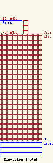
| Elevation Info |
Site Elevation: 375 meters (1230 ft) |
| Height of Structure: 48 meters (157 feet) |
| Overall Height Above Ground: 48 meters (157 feet) |
| Overall Height Above Mean Sea Level: 423 meters (1388 feet) |
| Owner Info | Riverfront Broadcasting of Iowa, LLC
3008 Mulligan Drive
Yankton, SD 57078
(605) 260-0793
doyleb@riverfrontbroadcasting.com |
| Contact Info | Riverfront Broadcasting of Iowa, LLC
3008 Mulligan Drive
Yankton, SD 57078
(605) 260-0793
doyleb@riverfrontbroadcasting.com |
