|
|
Antenna Structure Registration 1017308 |
 |
Registration Info | Registration Number: 1017308 |
| File Number: A1206300 |
| FAA Study: 2015-ACE-1356-OE |
| FAA Issue Date: 05/18/2015 |
| Status: Constructed |
| Date Constructed: 03/06/1996 |
| NEPA: N |
Structure Info
| Structure Type: GTOWER |
| Structure Coordinates: 42-26-32.0 N 92-23-49.0 W (NAD 83) |
| Structure Coordinates: 42-26-32.0 N 92-23-48.3 W (Converted to NAD 27) |
| Structure Address: 2035 W Shaulis Rd |
| Structure City: Waterloo, IA |
| Structure County: Black Hawk County |
| Painting & Lighting Info |
FAA Circular #: 70/7460-1H |
FAA Chapters: 3, 4, 5, 13 |
Remarks: PRIOR STUDY 1995-ACE-504-OE. FAA CHAPTERS 3,4,5,13, 70/7460-1H WITH FAA APPROVED BIRD DEVIATION SPECIAL CONDITION. |
| Elevation Info |
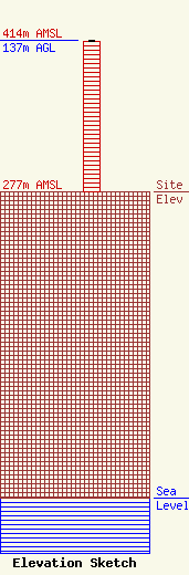
Site Elevation: 277 meters (909 ft) |
| Height of Structure: 136 meters (446 feet) |
| Overall Height Above Ground: 137 meters (449 feet) |
| Overall Height Above Mean Sea Level: 414 meters (1358 feet) |
| Owner Info | Townsquare Media Waterloo, LLC
1 Manhattanville Road
Purchase, NY 10577
(203) 861-0900
fcccontact@townsquaremedia.com |
| Contact Info | Townsquare Media Waterloo, LLC
1 Manhattanville Road
Purchase, NY 10577
(203) 861-0900
fcccontact@townsquaremedia.com |
