|
|
Antenna Structure Registration 1017309 |
 |
Registration Info | Registration Number: 1017309 |
| File Number: A1206301 |
| FAA Study: 2015-ACE-1357-OE |
| FAA Issue Date: 12/17/2015 |
| Status: Constructed |
| Date Constructed: 11/11/1987 |
| NEPA: N |
Structure Info
| Structure Type: GTOWER |
| Structure Coordinates: 42-40-56.7 N 91-52-50.7 W (NAD 83) |
| Structure Coordinates: 42-40-56.8 N 91-52-50.1 W (Converted to NAD 27) |
| Structure Address: 0.22 Mi N-333.75-e Of Intersection 35th & Neon Rd. |
| Structure City: Oelwein, IA |
| Structure County: Fayette County |
| Painting & Lighting Info |
FCC Paragraph(s): 1, 3, 7, 16, 21 |
Remarks: OM&L = Red Lights/Paint WITH BIRD LIGHTING DEVIATION SPECIAL CONDITION. PRIOR STUDY 1985-ACE-287-OE |
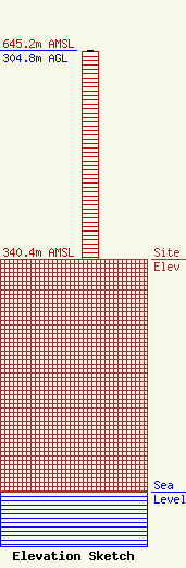
| Elevation Info |
Site Elevation: 340.4 meters (1117 ft) |
| Height of Structure: 303.9 meters (997 feet) |
| Overall Height Above Ground: 304.8 meters (1000 feet) |
| Overall Height Above Mean Sea Level: 645.2 meters (2117 feet) |
| Owner Info | Townsquare Media Waterloo, LLC
1 Manhattanville Road
Purchase, NY 10577
(203) 861-0900
fcccontact@townsquaremedia.com |
| Contact Info | Townsquare Media Waterloo, LLC
1 Manhattanville Road
Purchase, NY 10577
(203) 861-0900
fcccontact@townsquaremedia.com |
