|
|
Antenna Structure Registration 1017940 |
 |
Registration Info | Registration Number: 1017940 |
| File Number: A1132087 |
| FAA Study: 2017-ACE-2565-OE |
| FAA Issue Date: 11/08/2017 |
| Status: Constructed |
| Date Constructed: 01/01/1979 |
| NEPA: N |
Structure Info
| Structure Type: GTOWER |
| Structure Coordinates: 43-3-11.8 N 92-40-14.6 W (NAD 83) |
| Structure Coordinates: 43-03-11.9 N 92-40-13.9 W (Converted to NAD 27) |
| Structure Address: Stony Point Rd At Hwy 18 |
| Structure City: Charles City, IA |
| Structure County: Floyd County |
| Painting & Lighting Info |
FCC Paragraph(s): 1, 3, 12, 21 |
Remarks: Continue As Is OM&L = PAINT/RED LIGHTS |
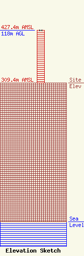
| Elevation Info |
Site Elevation: 309.4 meters (1015 ft) |
| Height of Structure: 118 meters (387 feet) |
| Overall Height Above Ground: 118 meters (387 feet) |
| Overall Height Above Mean Sea Level: 427.4 meters (1402 feet) |
| Owner Info | Coloff Media
721 Shirley Street
Cedar Falls, IA 50613
(319) 277-1918
jacoloff@hotmail.com |
| Contact Info | Coloff Media
721 Shirley Street
Cedar Falls, IA 50613
Jim Coloff
(319) 277-1918
jacoloff@hotmail.com |
