|
|
Antenna Structure Registration 1018185 |
 |
Registration Info | Registration Number: 1018185 |
| File Number: A1313141 |
| FAA Study: 2012-ANM-2131-OE |
| FAA Issue Date: 11/13/2012 |
| Status: Constructed |
| Date Constructed: 12/21/2012 |
| FAA EMI: N |
| NEPA: N |
Structure Info
| Structure Type: LTOWER |
| Structure Coordinates: 41-6-0.6 N 105-0-25.3 W (NAD 83) |
| Structure Coordinates: 41-06-00.7 N 105-00-23.4 W (Converted to NAD 27) |
| Structure Address: Us Hwy 30 10 Mi W |
| Structure City: Cheyenne, WY |
| Structure County: Laramie County |
| Painting & Lighting Info |
FCC Paragraph(s): 1 |
Remarks: Continue As Is OM&L = MARKED |
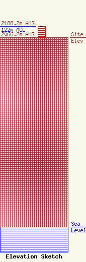
| Elevation Info |
Site Elevation: 2066.2 meters (6779 ft) |
| Height of Structure: 122 meters (400 feet) |
| Overall Height Above Ground: 122 meters (400 feet) |
| Overall Height Above Mean Sea Level: 2188.2 meters (7179 feet) |
| Owner Info | Marquee Broadcasting West, Inc.
2923 East Lincolnway
Cheyenne, WY 82001
(301) 661-9610
patricia_lane@marqueebroadcasting.com |
| Contact Info | BakerHostetler LLP
1050 Connecticut Ave NW
Washington, DC 20036
Daniel Kirkpatrick
(202) 861-1758
dkirkpatrick@bakerlaw.com |
