|
|
Antenna Structure Registration 1018464 |
 |
Registration Info | Registration Number: 1018464 |
| File Number: A1245403 |
| FAA Study: 2019-AGL-17116-OE |
| FAA Issue Date: 10/16/2019 |
| Status: Constructed |
| Date Constructed: 08/20/1996 |
| NEPA: N |
Structure Info
| Structure Type: GTOWER |
| Structure Coordinates: 41-4-58.5 N 81-38-1.6 W (NAD 83) |
| Structure Coordinates: 41-04-58.3 N 81-38-02.2 W (Converted to NAD 27) |
| Structure Address: 2101 S Cleveland Massillon Rd |
| Structure City: Copley, OH |
| Structure County: Summit County |
| Painting & Lighting Info |
FAA Circular #: 70/7460-1J |
FAA Chapters: 4, 7, 13 |
Remarks: OM&L to remain the same as prior studies = 24-HR HI-STROBES |
Remarks: PRIOR STUDIES 97-AGL-0843-OE / 1998-AGL-2414-OE |
Remarks: OM&L to remain the same as prior studies = 24-HR HI-STROBES |
Remarks: PRIOR STUDIES 97-AGL-0843-OE / 1998-AGL-2414-OE |
| Elevation Info |
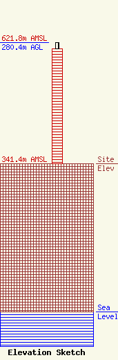
Site Elevation: 341.4 meters (1120 ft) |
| Height of Structure: 266.4 meters (874 feet) |
| Overall Height Above Ground: 280.4 meters (920 feet) |
| Overall Height Above Mean Sea Level: 621.8 meters (2040 feet) |
| Owner Info | Northeastern Educational Television of Ohio, Inc.
1750 W. Campus Center Drive
Kent, OH 44240
(330) 474-5022
rwheele@pbswesternreserve.org |
| Contact Info | Gray Miller Persh LLP
2233 Wisconsin Ave., NW
Washington, DC 20007
Derek Teslik
(202) 559-7489
dteslik@graymillerpersh.com |
