|
|
Antenna Structure Registration 1018769 |
 |
Registration Info | Registration Number: 1018769 |
| File Number: A1297304 |
| FAA Study: 92-AEA-2144-OE |
| FAA Issue Date: 01/14/1993 |
| Status: Constructed |
| Date Constructed: 07/01/1993 |
| NEPA: N |
Structure Info
| Structure Type: TOWER |
| Structure Coordinates: 37-59-1.0 N 78-28-53.0 W (NAD 83) |
| Structure Coordinates: 37-59-00.5 N 78-28-54.0 W (Converted to NAD 27) |
| Structure Address: In Carters Mountain Orchard E Of Rt 20 3.5 Mi S |
| Structure City: Charlottesville, VA |
| Structure County: Albemarle County |
| Painting & Lighting Info |
FAA Circular #: 70/7460-1H |
FAA Chapters: 3, 4, 5, 13 |
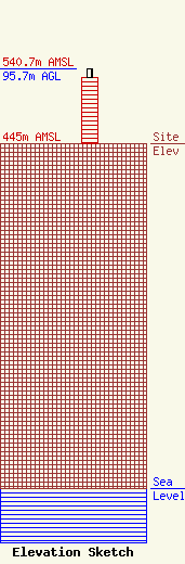
| Elevation Info |
Site Elevation: 445 meters (1460 ft) |
| Height of Structure: 85 meters (279 feet) |
| Overall Height Above Ground: 95.7 meters (314 feet) |
| Overall Height Above Mean Sea Level: 540.7 meters (1774 feet) |
| Owner Info | Gray Local Media, Inc.
4370 Peachtree Road, NE
Atlanta, GA 30319
(404) 266-8333
legalnotices@graymedia.com |
| Contact Info | Gray Local Media, Inc.
4370 Peachtree Road NE
Atlanta, GA 30319
Engineering Department
(404) 266-8333
legalnotices@graymedia.com |
