|
|
Antenna Structure Registration 1018776 |
 |
Registration Info | Registration Number: 1018776 |
| File Number: A1252191 |
| FAA Study: 01-ASO-1529-OE |
| FAA Issue Date: 02/26/2001 |
| Status: Constructed |
| Date Constructed: 09/01/1969 |
| FAA EMI: N |
| NEPA: N |
Structure Info
| Structure Type: TOWER |
| Structure Coordinates: 33-48-18.0 N 84-8-40.0 W (NAD 83) |
| Structure Coordinates: 33-48-17.6 N 84-08-40.3 W (Converted to NAD 27) |
| Structure Address: 2 Robert E Lee Blvd Atop Stone Mountain |
| Structure City: Stone Mountain, GA |
| Structure County: DeKalb County |
| Painting & Lighting Info |
FAA Circular #: 70/7460-1K |
FAA Chapters: 4, 8, 12 |
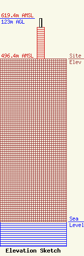
| Elevation Info |
Site Elevation: 496.4 meters (1629 ft) |
| Height of Structure: 95.1 meters (312 feet) |
| Overall Height Above Ground: 123 meters (404 feet) |
| Overall Height Above Mean Sea Level: 619.4 meters (2032 feet) |
| Owner Info | Georgia Public Telecommunications Commission
260 14th Street NW
Atlanta, GA 30318
(404) 685-2483
awoodlief@gpb.org |
| Contact Info | Gray Miller Persh LLP
2233 Wisconsin Ave., NW
Washington, DC 20007
Derek Teslik
(202) 559-7489
dteslik@graymillerpersh.com |
