|
|
Antenna Structure Registration 1019014 |
 |
Registration Info | Registration Number: 1019014 |
| File Number: A1344533 |
| FAA Study: 96-AGL-4129-OE |
| FAA Issue Date: 01/03/1997 |
| Status: Constructed |
| Date Constructed: 10/01/1987 |
| FAA EMI: N |
| NEPA: N |
Structure Info
| Structure Type: TOWER |
| Structure Coordinates: 39-6-59.0 N 84-30-7.0 W (NAD 83) |
| Structure Coordinates: 39-06-58.8 N 84-30-07.2 W (Converted to NAD 27) |
| Structure Address: 1906 Highland Ave |
| Structure City: Cincinnati, OH |
| Structure County: Hamilton County |
| Painting & Lighting Info |
FAA Circular #: 70/7460-1J |
FAA Chapters: 3, 4, 5, 13 |
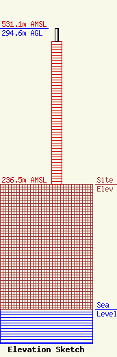
| Elevation Info |
Site Elevation: 236.5 meters (776 ft) |
| Height of Structure: 269.8 meters (885 feet) |
| Overall Height Above Ground: 294.6 meters (967 feet) |
| Overall Height Above Mean Sea Level: 531.1 meters (1742 feet) |
| Owner Info | Vertical Bridge CC FM, LLC
22 W Atlantic Avenue
Delray Beach, FL 33444
(561) 406-4015
fcc-faa@verticalbridge.com |
| Contact Info | Vertical Bridge CC FM, LLC
22 W Atlantic Avenue
Delray Beach, FL 33444
Richard Hickey
(561) 406-4015
fcc-faa@verticalbridge.com |
