|
|
Antenna Structure Registration 1019245 |
 |
Registration Info | Registration Number: 1019245 |
| File Number: A1309813 |
| FAA Study: 97-AGL-1090-OE |
| FAA Issue Date: 04/02/1997 |
| Status: Constructed |
| Date Constructed: 10/01/1989 |
| FAA EMI: N |
| NEPA: N |
Structure Info
|
| Structure Coordinates: 40-2-9.0 N 80-46-15.0 W (NAD 83) |
| Structure Coordinates: 40-02-08.7 N 80-46-15.7 W (Converted to NAD 27) |
| Structure Address: 56325 High Ridge Rd |
| Structure City: Bellaire, OH |
| Structure County: Belmont County |
| Painting & Lighting Info |
FAA Circular #: 70/7460-1J |
FAA Chapters: 3, 4, 5, 13 |
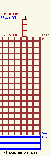
| Elevation Info |
Site Elevation: 393.2 meters (1290 ft) |
| Height of Structure: 68.5 meters (225 feet) |
| Overall Height Above Ground: 83.3 meters (273 feet) |
| Overall Height Above Mean Sea Level: 476.5 meters (1563 feet) |
| Owner Info | Ohio Midland Newsgroup LLC
3200 Guernsey Street
43906
Bellaire, OH 43906
(740) 312-3516
codybarack17@outlook.com |
| Contact Info | Ohio Midland Newsgroup
3200 Guernsey Street
Bellaire, OH 43906
Cody Barack
(740) 312-3516
codybarack17@outlook.com |
