|
|
Antenna Structure Registration 1020429 |
 |
Registration Info | Registration Number: 1020429 |
| File Number: A1297310 |
| FAA Study: 2002-ASW-3275-OE |
| FAA Issue Date: 09/18/2002 |
| Status: Constructed |
| Date Constructed: 05/20/2003 |
| FAA EMI: N |
| NEPA: N |
Structure Info
|
| Structure Coordinates: 30-26-37.0 N 91-10-54.0 W (NAD 83) |
| Structure Coordinates: 30-26-36.3 N 91-10-53.6 W (Converted to NAD 27) |
| Structure Address: 844 Government St |
| Structure City: Baton Rouge, LA |
| Structure County: East Baton Rouge Parish |
| Painting & Lighting Info |
FAA Circular #: 70/7460-1K |
FAA Chapters: 4, 5, 12 |
| Elevation Info |
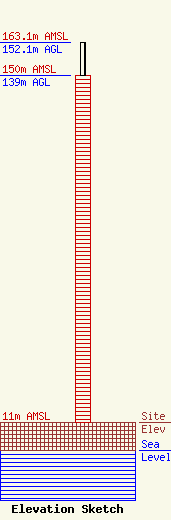
Site Elevation: 11 meters (36 ft) |
| Height of Structure: 139 meters (456 feet) |
| Overall Height Above Ground: 152.1 meters (499 feet) |
| Overall Height Above Mean Sea Level: 163.1 meters (535 feet) |
| Owner Info | Gray Local Media, Inc.
4370 Peachtree Road, NE
Atlanta, GA 30319
(404) 266-8333
legalnotices@graymedia.com |
| Contact Info | Gray Local Media, Inc.
4370 Peachtree Road NE
Atlanta, GA 30319
Engineering Department
(404) 266-8333
legalnotices@graymedia.com |
