|
|
Antenna Structure Registration 1020645 |
 |
Registration Info | Registration Number: 1020645 |
| File Number: A1141410 |
| FAA Study: 87-ASW-0092-OE |
| FAA Issue Date: 03/13/1987 |
| Status: Constructed |
| Date Constructed: 03/05/1987 |
| NEPA: N |
Structure Info
| Structure Type: TOWER |
| Structure Coordinates: 29-55-53.0 N 90-21-57.0 W (NAD 83) |
| Structure Coordinates: 29-55-52.3 N 90-21-56.7 W (Converted to NAD 27) |
| Structure Address: Se Corner La Hwy 52 & Tx Pacific Rr |
| Structure City: Luling, LA |
| Structure County: St. Charles Parish |
| Painting & Lighting Info |
FAA Circular #: 70/7460-1G |
FAA Chapters: 3, 4, 5, 9 |
Remarks: RED LIGHTS/PAINT |
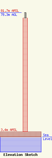
| Elevation Info |
Site Elevation: 3.4 meters (11 ft) |
| Height of Structure: 74.7 meters (245 feet) |
| Overall Height Above Ground: 78.3 meters (257 feet) |
| Overall Height Above Mean Sea Level: 81.7 meters (268 feet) |
| Owner Info | Entergy Services, LLC
425 West Capitol Ave.
551
Little Rock, AR 72203-0551
(501) 377-5609
TelecomMgr@Entergy.com |
| Contact Info | Entergy Services, LLC
425 West Capitol Ave.
551
Little Rock, AR 72203-0551
Steven Paquette
(501) 377-5609
TelecomMgr@Entergy.com |
