|
|
Antenna Structure Registration 1020785 |
 |
Registration Info | Registration Number: 1020785 |
| File Number: A1387890 |
| FAA Study: 2026-ACE-1891-OE |
| FAA Issue Date: 05/28/2026 |
| Status: Granted |
| Date Constructed: 05/01/1986 |
| NEPA: N |
Structure Info
| Structure Type: GTOWER |
| Structure Coordinates: 38-34-27.9 N 90-19-31.9 W (NAD 83) |
| Structure Coordinates: 38-34-27.7 N 90-19-31.5 W (Converted to NAD 27) |
| Structure Address: 7555 Mackenzie Road (st. Louis Mo 4 #305889) |
| Structure City: Saint Louis, MO |
| Structure County: St. Louis County |
| Painting & Lighting Info |
FAA Circular #: 70/7460-1M |
FAA Chapters: 4, 9, 15 |
Remarks: PRIOR STUDY 2011-ACE-465-OE |
| Elevation Info |
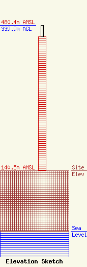
Site Elevation: 140.5 meters (461 ft) |
| Height of Structure: 313.9 meters (1030 feet) |
| Overall Height Above Ground: 339.9 meters (1115 feet) |
| Overall Height Above Mean Sea Level: 480.4 meters (1576 feet) |
| Owner Info | American Towers LLC
10 Presidential Way
Woburn, MA 01801
(781) 926-4500
faa-fcc@americantower.com |
| Contact Info | American Towers LLC
10 Presidential Way
Woburn, MA 01801
(781) 926-4500
faa-fcc@americantower.com |
