|
|
Antenna Structure Registration 1021870 |
 |
Registration Info | Registration Number: 1021870 |
| File Number: A1341891 |
| FAA Study: 2014-ANE-2394-OE |
| FAA Issue Date: 02/24/2015 |
| Status: Constructed |
| Date Constructed: 01/01/1948 |
| NEPA: N |
Structure Info
| Structure Type: GTOWER |
| Structure Coordinates: 41-48-17.0 N 71-28-22.0 W (NAD 83) |
| Structure Coordinates: 41-48-16.6 N 71-28-23.8 W (Converted to NAD 27) |
| Structure Address: Ipswitch St On Neutaconkanut Hill |
| Structure City: Johnston, RI |
| Structure County: Providence County |
| Painting & Lighting Info |
FCC Paragraph(s): 1, 3, 4, 13, 21 |
Remarks: Continue As Is OM&L = PAINT/RED LIGHTS |
Remarks: PRIOR STUDY 1985-ANE-9-OE |
Remarks: Continue As Is OM&L = PAINT/RED LIGHTS |
Remarks: PRIOR STUDY 1985-ANE-9-OE |
| Elevation Info |
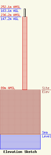
Site Elevation: 89 meters (292 ft) |
| Height of Structure: 147.2 meters (483 feet) |
| Overall Height Above Ground: 163.1 meters (535 feet) |
| Overall Height Above Mean Sea Level: 252.1 meters (827 feet) |
| Owner Info | VB Nimbus, LLC
22 W Atlantic Avenue
Delray Beach, FL 33444
(561) 406-4015
fcc-faa@verticalbridge.com |
| Contact Info | VB Nimbus, LLC
22 W Atlantic Avenue
Delray Beach, FL 33444
Richard Hickey
(561) 406-4015
fcc-faa@verticalbridge.com |
