|
|
Antenna Structure Registration 1022315 |
 |
Registration Info | Registration Number: 1022315 |
| File Number: A1298763 |
| FAA Study: 2018-ANE-715-OE |
| FAA Issue Date: 02/21/2018 |
| Status: Dismantled |
| Date Constructed: 10/01/1995 |
| NEPA: N |
Structure Info
| Structure Type: GTOWER |
| Structure Coordinates: 44-7-35.6 N 69-8-16.0 W (NAD 83) |
| Structure Coordinates: 44-07-35.3 N 69-08-17.9 W (Converted to NAD 27) |
| Structure Address: 165 West Meadow Road - Benner Hill |
| Structure City: Rockland, ME |
| Structure County: Knox County |
| Painting & Lighting Info |
FAA Circular #: 70/7460-1L |
FAA Chapters: 3, 4, 5, 12 |
Remarks: PRIOR STUDY 1994-ANE-357-OE |
| Elevation Info |
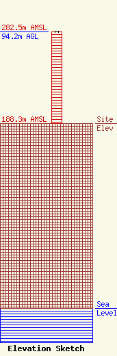
Site Elevation: 188.3 meters (618 ft) |
| Height of Structure: 94.2 meters (309 feet) |
| Overall Height Above Ground: 94.2 meters (309 feet) |
| Overall Height Above Mean Sea Level: 282.5 meters (927 feet) |
| Owner Info | Blueberry Broadcasting, LLC
3059
Kennebunkport, ME 04046
(207) 967-6161
louis@marinertower.com |
| Contact Info | Blueberry Broadcasting, LLC
3059
Kennebunkport, ME 04046
Louis Vitali
(207) 967-6161
louis@marinertower.com |
