|
|
Antenna Structure Registration 1022597 |
 |
Registration Info | Registration Number: 1022597 |
| File Number: A0026978 |
| FAA Study: 97-ASW-2306-OE |
| FAA Issue Date: 09/09/1997 |
| Status: Constructed |
| Date Constructed: 03/01/1990 |
| NEPA: N |
Structure Info
| Structure Type: TOWER |
| Structure Coordinates: 31-34-8.0 N 93-29-5.0 W (NAD 83) |
| Structure Coordinates: 31-34-07.4 N 93-29-04.4 W (Converted to NAD 27) |
| Structure Address: 605 San Antonio Ave |
| Structure City: Many, LA |
| Structure County: Sabine Parish |
| Painting & Lighting Info |
FAA Chapters: NONE |
Remarks: Removed expiration date from determination. Scenario 1./jjs/case#635066 |
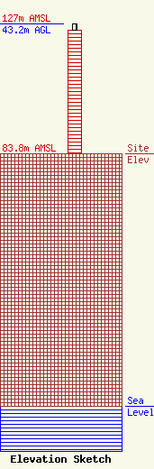
| Elevation Info |
Site Elevation: 83.8 meters (275 ft) |
| Height of Structure: 41.1 meters (135 feet) |
| Overall Height Above Ground: 43.2 meters (142 feet) |
| Overall Height Above Mean Sea Level: 127 meters (417 feet) |
| Owner Info | ILLINI CABLEVISION OF SABINE INC
595 SAN ANTONIO AVE
MANY, LA 71449
(318) 256-2097
|
