|
|
Antenna Structure Registration 1022810 |
 |
Registration Info | Registration Number: 1022810 |
| File Number: A1367148 |
| FAA Study: 2008-ASW-4853-OE |
| FAA Issue Date: 07/11/2008 |
| Status: Constructed |
| Date Constructed: 01/01/1986 |
| FAA EMI: N |
| NEPA: N |
Structure Info
| Structure Type: TOWER |
| Structure Coordinates: 30-19-34.6 N 91-16-36.1 W (NAD 83) |
| Structure Coordinates: 30-19-33.9 N 91-16-35.7 W (Converted to NAD 27) |
| Structure Address: 1.9 Mi W Of St Hwy 1 On Hwy 1148 |
| Structure City: Addis, LA |
| Structure County: West Baton Rouge Parish |
| Painting & Lighting Info |
FAA Circular #: 70/7460-1K |
FAA Chapters: 4, 7, 12 |
Remarks: PRIOR STUDY 1987-ASW-812-OE |
| Elevation Info |
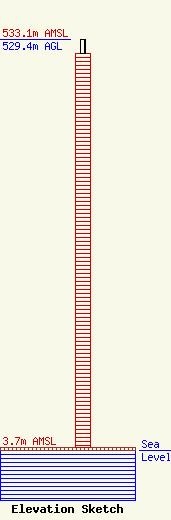
Site Elevation: 3.7 meters (12 ft) |
| Height of Structure: 511.1 meters (1677 feet) |
| Overall Height Above Ground: 529.4 meters (1737 feet) |
| Overall Height Above Mean Sea Level: 533.1 meters (1749 feet) |
| Owner Info | Pinnacle Towers LLC
2000 Corporate Drive
Canonsburg, PA 15317
(724) 416-2400
Regulatory.Department@crowncastle.com |
| Contact Info | Crown Castle
2000 Corporate Drive
Canonsburg, PA 15317
Tom Anderson
(724) 743-6330
Tom.Anderson@crowncastle.com |
